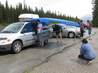
 As we left Lake Louise the weather was overcast and there were intermittent showers. The weather seemed to clear slightly as we headed towards Jasper, some 230 kms along the Icefields Parkway. Along the way we stopped at most viewpoints, and finally stopped for some lunch at the Crowfoot Glacier. It looked like there was a possibility of a shower, and we had planned to cook some sausages, and eat like hotdogs. I got a small tarpaulin out of the car, and to the horror and embarrassment of Bridget and Daniel, began to tie it to the roof racks and set up poles and tent pegs, so that it looked like a makeshift annex. Someone even asked as they walked by if we were setting up a stall.
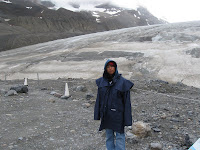
When we got to the Athabasca Glacier it was late in the afternoon and the breeze was quite cool. We put on jackets and walked up towards the toe of the glacier. It has receded m
 ore than 1.5 km in the past 125 years and lost over half of its volume. It currently recedes at a rate of 2-3 metres per year. That means that since we were last here in 2001, it has receded about 20 metres. We were able to walk on the toe of tha glacier last time we were here, but you are now prohibited from going on it because of the danger. It has formed a lake and a fast moving stream under the ice. At about the same time as we were her in 2001, a nine year old boy was walking one the glacier, and he fell down a crevasse. By the time the rescuers got him out, he was dead through exposure and hypothermia. The glacier is one of 6 main toes of the Columbian Icefields. Water melting from this icefield can end up in one of 3 oceans depending on which river it follows. The 3 main rivers are: the Columbia, which empties in to the Pacific ocean at the Oregon and Washington border; the Saskatchewan which heads to Lake Winnipeg and eventually Hudson's Bay and the Atlantic Ocean; and the Athabasca River which heads towards the Arctic Ocean.
 The sun didn't set until after 10 pm. so there was plenty of light in the day to continue and stop at the waterfalls and other view points. One of the most exciting events was the sighting of a black bear foraging for food on the steep side of the road. It was about 50 metres up a slope and walking along parallel to the road.
We were a bit worried about whether we were going to be able to find a camping spot in Jasper, but luckily there was space in the Whistlers Campground just a few kms. short of Jasper. We set up camp, lit a fire, had dinner and ate S'mores around the fire.
The next day we packed up and headed in to Jasper. We spent time exploring the shops and replenished our food stores for lunch. We then headed towards Maligne Canyon and Lake, where the info guides suggest there are good chances of seeing local wildlife.
We stopped and explored Maligne Canyon,
 where the Maligne River has cut it's way through the rocks on it's journey from Maligne Lake to the Athabasca River. As we headed further up the valley we spotted two male elk. They had about 4 tines on each antler. We watched as they nibbled on trees and buushes along the side of the road, crossed the road, and continued until they disappeared into the bushes. A little bit further along the road we saw a couple of cars stopped. They were looking at another bear turning over rocks looking for food. Another photo opportunity, or as Daniel reminded us, that the rangers had men
 tioned at the ranger talk at Lake Louise, we shouldn't stop, and should minimise our contact with the wildlife because they will get too used to people, and can lead to danger - cars etc. On the return trip we saw a huge male elk with 7 tines on one antler, and 8 on the other.
We left Jasper at about 5 pm. and started to head for home. We took the Yellowhead Highway towards Revelstoke. Great scenery everywhere you look. We kept ssing signs to beware of moose for the next 15 km, or 20 km,. so we were on the lookout. We didn't see any. We did pass a wayside stop where we saw a bear walking through. We slowed and noticed that it was walking over to a small grassed area where there was another bear.
 They both began digging in the sandy grassed area obviously looking for food. We took some pictures and continued on our way. As it was getting towards sundown i noticed a shape on the side of the road ahead of us. It turned out to be a female moose walking along the side of the road towards us. As it got closer, it turned in to the bush and
  disappeared up the hill.
We started talking about where we would camp for the night and I started to see flashes of lightning all around. We decided not to camp, so we had a quick hamburger at the local DQ, and drove through the night getting home at around 3:00 am.


No comments:
Post a Comment